
Introduction: Why Accurate Spatial Data Matters
In an era defined by rapid urbanisation, large-scale infrastructure rollouts, and data-driven decision-making, accurate spatial data has become a foundational business asset. Whether you are planning a highway corridor, developing a smart township, managing utility networks, or assessing agricultural land, the quality and speed of your location intelligence directly determines project outcomes.
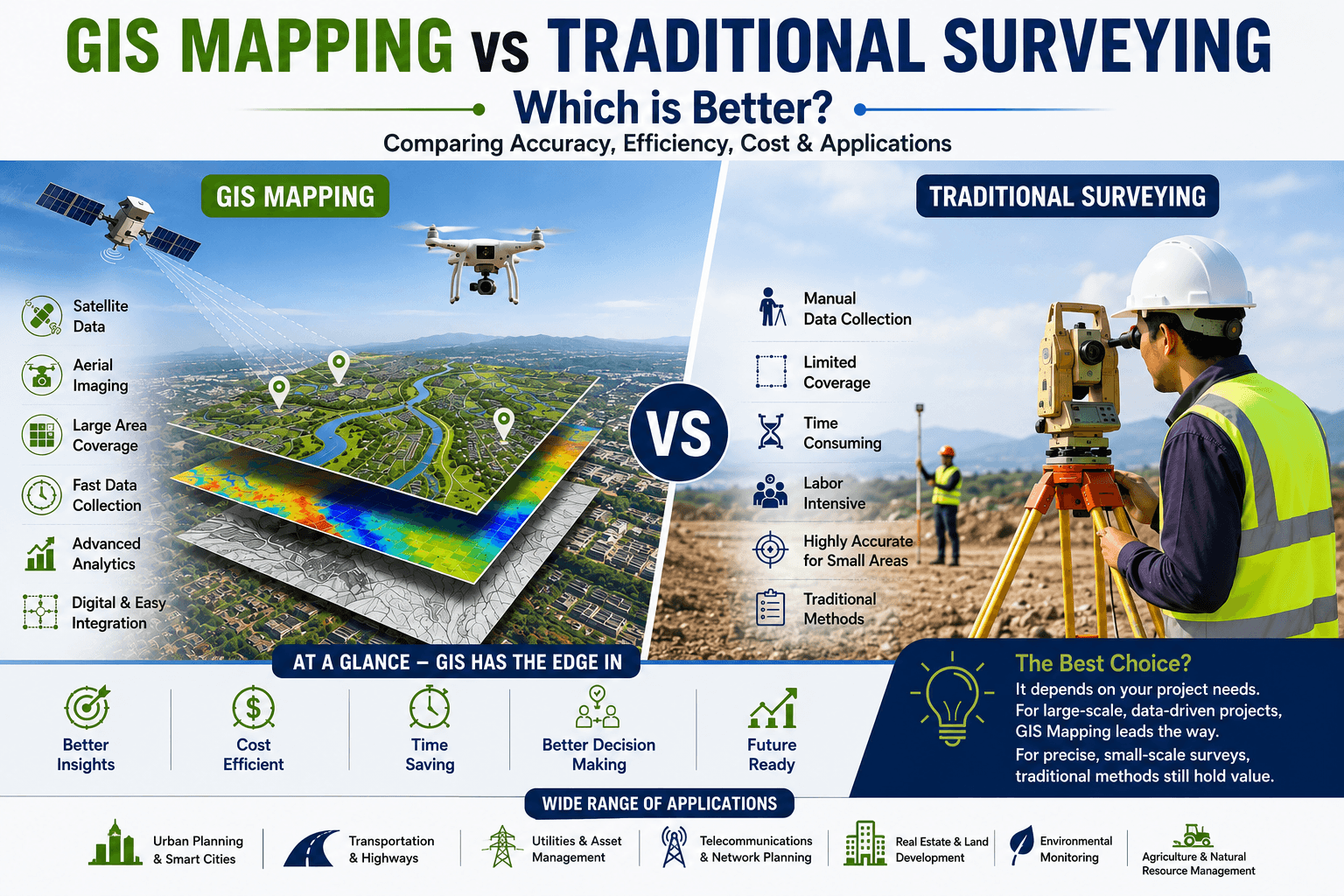
Two primary methodologies compete for this role: traditional surveying and GIS mapping. Traditional land surveying has been the backbone of civil engineering and real estate for centuries, delivering precise boundary and topographic data. GIS mapping, powered by GPS, satellite imagery, drones, LiDAR, and cloud-based geospatial platforms, is rapidly transforming how organisations collect, analyse, and act on spatial information.
So when it comes to GIS mapping vs traditional surveying, which is the right choice for your project? The honest answer depends on scale, purpose, budget, and regulatory requirements. This article breaks down both approaches in depth, compares them across critical parameters, and shows you exactly when to use each — and when to combine them.
What is Traditional Surveying?
Traditional surveying is the practice of measuring and recording the physical features of the earth's surface using ground-based instruments and techniques. It has been used for millennia to establish property boundaries, create topographic maps, and support construction projects.
Common Methods
• Plane surveying — for small areas where earth curvature is negligible
• Geodetic surveying — for large-scale national mapping
• Topographic surveying — measuring terrain features and elevations
• Cadastral (boundary) surveying — defining legal property lines
• Construction surveying — staking out building footprints and alignments
Equipment Used
• Total stations and theodolites
• GPS/GNSS receivers for ground control
• Levelling instruments
• Electronic Distance Measurement (EDM) devices
• Measuring tapes, rods, and staffs
Typical Use Cases
Traditional surveying is the standard for property demarcation, court-admissible boundary disputes, small-scale construction layouts, and any situation requiring legally certified survey data. In India, it remains the primary method recognised by revenue departments for land records (patta, khata, mutation), making it indispensable for real estate title verification and urban local body approvals.
What is GIS Mapping?
Geographic Information System (GIS) mapping is the process of capturing, storing, analysing, and visualising geospatial data using digital technologies. Unlike traditional surveying, which produces point or line measurements, GIS integrates multiple data layers — terrain, infrastructure, demographics, environmental conditions — into a unified spatial platform.
Technologies Involved
• GPS and GNSS for precise positioning
• Satellite imagery from platforms such as WorldView, Sentinel, and ISRO's Cartosat
• Drone (UAV) photogrammetry for high-resolution aerial surveys
• LiDAR (Light Detection and Ranging) for 3D point cloud generation
• GIS software platforms: ESRI ArcGIS, QGIS, Google Earth Engine, MapInfo
• Cloud-based geospatial APIs and real-time data streams
Benefits of Digital Geospatial Data
GIS mapping converts raw spatial observations into actionable intelligence. Data layers can be overlaid, queried, and updated in real time, enabling organisations to monitor change over time, model future scenarios, and automate reporting. For large infrastructure firms, smart city planners, and utility companies, GIS is not just a mapping tool — it is a decision support system.
GIS Mapping vs Traditional Surveying: Key Differences
The table below provides a comprehensive comparison across the parameters that matter most to business and project decision-makers:
Feature | GIS Mapping | Traditional Surveying |
Accuracy | High (sub-metre with GPS/LiDAR) | Very High (mm-level precision) |
Data Collection Speed | Fast — large areas in hours | Slow — manual, field-intensive |
Coverage Area | Regional to national scale | Limited to small/defined zones |
Cost Efficiency | Lower cost per sq. km at scale | Higher cost for large areas |
Scalability | Highly scalable | Limited scalability |
Data Visualisation | Rich 2D/3D maps, dashboards | Basic drawings & reports |
Data Analysis | Advanced spatial analytics | Limited analytical capability |
Real-Time Updates | Yes — live data integration | No — static snapshots |
Legal Acceptance | Growing; varies by jurisdiction | Universally accepted |
Long-Term Maintenance | Digital — easy to update | Paper/CAD — costly to revise |
Advantages of Traditional Surveying
Exceptional Precision for Boundary Work
For property boundary surveys, traditional methods can achieve millimetre-level accuracy that no current remote sensing technology can match at the individual plot level. This level of precision is critical when disputes arise or when engineering tolerances are extremely tight.
Legal and Regulatory Acceptance
In India and across most jurisdictions globally, traditional survey data certified by a licensed surveyor carries legal weight. Revenue departments, courts, municipal bodies, and lending institutions all recognise traditional survey documentation. For any project involving land acquisition, titling, or statutory approvals, traditional survey output is often mandatory.
Suitability for Small-Scale Projects
For a single building plot, a road widening of a few hundred metres, or a small industrial shed layout, traditional surveying is fast, cost-effective, and proportionate. Deploying a full GIS platform for a 500 sq. m. plot layout would be over-engineering the solution.
Advantages of GIS Mapping
Large-Area Coverage at Scale
A single drone or satellite pass can cover thousands of hectares in a day. For infrastructure corridors, river basin studies, forest monitoring, or district-level urban planning, GIS mapping delivers coverage that would take traditional survey teams months or years to replicate.
Faster Data Processing and Reporting
Modern GIS platforms process field data automatically, generating orthorectified maps, digital elevation models (DEMs), and spatial analyses within hours of data capture. This dramatically accelerates planning cycles.
Real-Time Updates and Change Detection
GIS enables ongoing monitoring. Satellite or drone data captured at regular intervals can automatically flag changes — encroachments on infrastructure corridors, illegal construction, crop health shifts, or network damage after a natural disaster.
Superior Decision Support and Visualisation
GIS data can be presented as interactive dashboards, 3D city models, heat maps, and scenario simulations. Business leaders and government officials can explore spatial insights without needing to interpret raw engineering drawings.
Integration with Business Systems
Modern GIS platforms integrate with ERP, asset management, BIM (Building Information Modelling), and IoT sensor networks. This allows spatial data to flow directly into operational workflows — from maintenance scheduling to emergency response.
Smart City and Infrastructure Applications
GIS is the spatial backbone of smart city initiatives. Traffic management, utility network planning, disaster risk mapping, public health spatial analysis, and environmental compliance monitoring all depend on GIS infrastructure.
When Should Businesses Choose Traditional Surveying?
Traditional surveying is the right choice in the following scenarios:
• Property boundary demarcation for legal registration or dispute resolution — e.g., a developer acquiring agricultural land parcels in Pune requiring mutation records
• Construction set-out surveys for precise alignment of foundations, columns, and structural elements
• Compliance with state revenue department requirements in India — e.g., obtaining survey sketches for EC (Encumbrance Certificate) clearance
• Small site feasibility studies where total survey area is under 5–10 acres
• Underground utility surveys requiring precise depth and location data with legal certification
Example: A real estate developer in Chennai needs to register a residential layout of 3 acres. The revenue authority requires a certified traditional survey sketch with plot bearings. Traditional surveying is mandatory here.
When Should Businesses Choose GIS Mapping?
GIS mapping delivers superior value when:
• Large area coverage is needed — e.g., a 200 km highway corridor alignment study in Rajasthan
• Multiple data layers need integration — overlaying utility networks, land use, flood zones, and demographics for a township master plan
• Ongoing monitoring is required — tracking construction progress across multiple project sites from a central command centre
• Rapid data turnaround is critical — a telecom company planning tower rollout across 50 districts needs site feasibility maps within days
• 3D visualisation and stakeholder presentation are required — presenting a metro rail alignment to civic bodies with an interactive 3D model
• Asset management needs spatial intelligence — utilities mapping distribution networks for maintenance and emergency response
Example: An infrastructure firm bidding for a 500 km transmission line project in Madhya Pradesh uses GIS mapping to analyse terrain, identify sensitive zones (forest reserves, flood plains), optimise tower placement, and generate a corridor feasibility report — all within two weeks.
Combining GIS Mapping and Traditional Surveying
The most effective modern projects do not treat these methods as alternatives — they combine them strategically. This integrated approach is increasingly adopted by leading infrastructure firms, smart city agencies, and geospatial consultancies.
How Integration Works in Practice
• GIS mapping is used first for macro-level planning, corridor analysis, and site shortlisting, reducing field survey effort to specific locations
• Traditional surveys are then deployed for precise boundary setting, structural set-out, and legal documentation at the site level
• GIS incorporates traditional survey data as a high-accuracy control layer, improving overall dataset quality
• Digital twins are built using GIS as the spatial framework, with survey-accurate asset positions embedded
This hybrid model is particularly effective for large real estate developments, transport projects, and utility upgrades, where both planning-scale spatial analysis and parcel-level legal precision are required at different project stages.
Industry Applications Across Sectors
Urban Planning
Municipal corporations and urban development authorities use GIS to manage land use, model population growth, plan infrastructure upgrades, and identify areas at risk from flooding or seismic activity. India's AMRUT and Smart Cities Mission both mandate GIS-based city master planning.
Transportation and Infrastructure
Highway, metro, and port authorities deploy GIS for route alignment, right-of-way acquisition mapping, construction monitoring, and asset lifecycle management. The National Highways Authority of India (NHAI) uses GIS to manage over 140,000 km of highway network data.
Utilities and Energy
Power distribution companies, water utilities, and gas pipeline operators use GIS to map networks, plan maintenance, track outages, and manage regulatory compliance. Location intelligence reduces emergency response times and capital expenditure on network expansion.
Telecommunications
Telecom companies use GIS to plan 4G/5G tower locations, model signal coverage, assess line-of-sight constraints, and manage the rollout of new infrastructure across urban and rural geographies.
Real Estate and Construction
Developers and construction firms use GIS for site selection, market analysis, shadow and view studies, underground utility mapping, and BIM integration. GIS data underpins investor presentations, feasibility reports, and regulatory submissions.
Environmental Monitoring and Agriculture
Government agencies and agribusinesses use satellite-based GIS to monitor deforestation, water body changes, soil moisture, and crop health at scale. Precision agriculture applications deliver yield optimisation and input cost reduction across millions of hectares.
Future Trends in Geospatial Technology
Drone Mapping and Autonomous UAVs
Drone surveys are becoming faster, cheaper, and more accurate. Autonomous drone fleets can survey large areas without human pilots, integrating real-time data into GIS platforms. The Indian government's Drone Rules 2021 and the SVAMITVA scheme are accelerating drone-based land mapping across rural India.
AI-Powered Geospatial Analysis
Artificial intelligence is transforming GIS analytics. Machine learning models now automatically classify land cover, detect changes, identify infrastructure defects from aerial imagery, and predict spatial trends — tasks that previously required months of manual analysis.
Digital Twins
Digital twin technology creates real-time virtual replicas of physical infrastructure, cities, and environments using GIS as the spatial foundation. These models allow engineers, planners, and operators to simulate scenarios, test interventions, and monitor conditions continuously.
Smart Cities and IoT Integration
As Indian cities deploy IoT sensors for traffic, air quality, water management, and public safety, GIS platforms serve as the integration layer — connecting sensor streams to spatial maps and dashboards for real-time urban intelligence.
LiDAR Integration and 3D City Models
Airborne and mobile LiDAR systems are enabling the creation of precise 3D models of urban areas, forests, and infrastructure corridors. These models support advanced engineering analysis, including flood modelling, shadow studies, and structural clearance assessment.
Conclusion: Choosing the Right Approach for Your Project
The debate around GIS mapping vs traditional surveying does not have a universal winner — the best approach depends on your project's scale, regulatory requirements, budget, and data needs.
Traditional surveying remains essential for legal boundary work, small-scale construction set-out, and regulatory compliance. Its millimetre-level precision and legal acceptance make it irreplaceable for specific applications.
GIS mapping, however, is the undisputed choice for large-area coverage, complex multi-layer analysis, smart city applications, and any scenario where speed, scalability, and data visualisation are priorities. It is not a replacement for traditional surveying — it is a transformative layer of spatial intelligence that sits above it.
For most modern projects — particularly in infrastructure, real estate, utilities, and government — the optimal strategy combines both: GIS for strategic planning and monitoring, traditional surveying for legally precise ground control and boundary definition.
Organisations that invest in integrated geospatial capabilities today will be better positioned to compete, comply, and deliver in an increasingly data-driven built environment.
Ready to Leverage GIS Mapping for Your Next Project? At 99 Visual Solutions, we specialise in advanced GIS mapping, geospatial analysis, digital mapping, and data visualisation services tailored for construction, real estate, infrastructure, government, and enterprise clients across India and globally. Whether you need drone surveys, LiDAR processing, interactive GIS dashboards, or complete spatial data solutions, our expert team is ready to help. Contact 99 Visual Solutions today to discuss your project requirements and discover how our geospatial expertise can accelerate your decision-making, reduce costs, and deliver results at scale. |
Frequently Asked Questions (FAQs)
Q1. Is GIS mapping more accurate than traditional surveying? Not universally. Traditional surveying achieves higher accuracy for individual property boundaries and structural set-out (millimetre-level), while GIS mapping offers superior accuracy across large areas. Modern GIS systems using GNSS and LiDAR can achieve sub-metre accuracy, which is sufficient for most planning, infrastructure, and utility applications. For legally precise boundary demarcation, traditional surveying remains the standard. |
Q2. Is GIS mapping legally accepted in India? GIS data is increasingly used in Indian statutory processes, including the SVAMITVA scheme, Smart Cities Mission, AMRUT, and NHAI highway planning. However, for land registration, property mutation, and revenue records, a certified traditional survey conducted by a licensed surveyor is still required by most state revenue departments. This is evolving as states digitise land records. |
Q3. Which is more cost-effective for large infrastructure projects? GIS mapping is significantly more cost-effective at scale. The cost per square kilometre for drone or satellite-based GIS survey is a fraction of what equivalent ground-based traditional surveying would cost. For projects covering hundreds of kilometres or thousands of hectares, GIS mapping can reduce data collection costs by 60-80% while delivering faster results. |
Q4. Can GIS mapping and traditional surveying be used together? Yes — and this is the recommended approach for most complex projects. GIS mapping is used for macro-level planning, corridor analysis, and ongoing monitoring, while traditional surveying handles precise boundary demarcation, construction set-out, and legal documentation. The data from both methods is integrated into a unified GIS platform to create a complete spatial information system. |
Q5. What GIS mapping services does 99 Visual Solutions offer? 99 Visual Solutions provides end-to-end GIS mapping and geospatial services including drone survey and photogrammetry, LiDAR data processing, satellite image analysis, GIS database development, digital mapping, spatial data visualisation, and custom GIS application development. We serve construction companies, infrastructure firms, real estate developers, government agencies, utilities, and telecom operators across India and international markets. |